


TBPLIVE
Descrizione di TBPLIVE
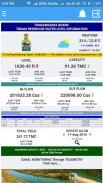
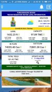
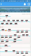
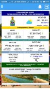
Welcome to the Tungabhadra Board, Reservoir Storage Management System Portal. The River Tungabhadra derives its name from two streams viz., the Tunga,
about 147 km(91.6 miles) long and the Bhadra, about 178 Km (110.9 miles) long which rise in the Western Ghats. The river after the influence of the two streams near Shimoga,
runs for about 531 Km(330 miles) till it joins the river Krishna at Sangamaleshwaram in Andhra Pradesh. It runs for 382 Km (237 miles) in Karnataka, forms the boundary between
Karnataka and Andhra Pradesh for58 Km (36 miles) and further runs for the next 91 Km (57 miles) in Andhra Pradesh. The total catchment area of the river is 69,552 Sq Km
(26,856 Sq miles) up to its confluence with Krishnaand it is 28,177 Sq Km (10,880 Sq miles) up to Tungabhadra Dam. It is influenced chiefly by the South-West monsoon. It is a
perennial river but the summer flows dwindle to as low as 2.83 to1.42 cumec (100 to 50 cusec).
Benvenuti nel consiglio di Tungabhadra, portale del sistema di gestione dello stoccaggio delle riserve. Il fiume Tungabhadra prende il nome da due torrenti, il Tunga,
circa 147 km (91.6 miglia) di lunghezza e il Bhadra, lungo circa 178 Km (110.9 miglia) che si elevano nei Ghati occidentali. Il fiume dopo l'influenza dei due torrenti vicino a Shimoga,
corre per circa 531 km (330 miglia) fino a quando si unisce al fiume Krishna a Sangamaleshwaram in Andhra Pradesh. Corre per 382 Km (237 miglia) in Karnataka, forma il confine tra
Karnataka e Andhra Pradesh per58 Km (36 miglia) e proseguono per i successivi 91 Km (57 miglia) in Andhra Pradesh. Il bacino idrografico totale del fiume è di 69.552 kmq
(26.856 miglia quadrate) fino alla sua confluenza con Krishnaand è 28.177 Sq Km (10.880 Sq miglia) fino alla diga di Tungabhadra. È influenzato principalmente dal monsone sud-occidentale. È un
fiume perenne ma i flussi estivi scendono fino a 2,83-1,42 mcec (da 100 a 50 cusec).
TBPLIVE - Versione 9.2
(26-03-2021)TBPLIVE - Informazioni APK
Versione APK: 9.2Pacchetto: tbapp.apzxnUltima versione di TBPLIVE


App nella stessa categoria

Potrebbe piacerti anche...


